|
|
 |
r
u
n
b
l
o
g |
Pac Tom update: March 2008
(30 Mar 2008 at 16:04) |
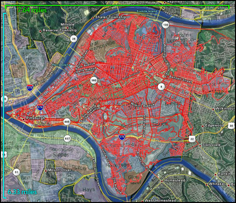
1007×867 version
I haven't done one of these updates in a while. I slowed a bit while I was writing my dissertation (also it was cold and I do not really want to run in snow or on ice) but never gave up! Recently I have been getting serious again, running a long trip (usually 13–17 miles) almost every weekend. These long ones are basically a necessity now, since it's a (say) 7 mile minimum trip just to get to (say) downtown and back, and that's on roads I've already done! Long is fun, though. I'd like to be able to run a marathon this year, and if I can find some solution to this knee pain that comes on at like mile 15, I think it is within my grasp.
So if you flip between this and my first post on the subject you can see my progress in 11 months. Not too shabby. (In that post I claim knee pain after 10 miles. Maybe it is getting stronger then?) I like how the network of routes diverge like blood vessels from my apartment in Shadyside. Some numbers: I've run 1533.5 miles total in 8 days, 18 hours, 51 minutes. Certainly not all of that is for Pac Tom, but most is. I think I have gone through 5 pairs of sneakers since starting ($620!). | |
|
r
u
n
b
l
o
g |
Pac Tom update: The periphery
(16 Aug 2007 at 19:51) |
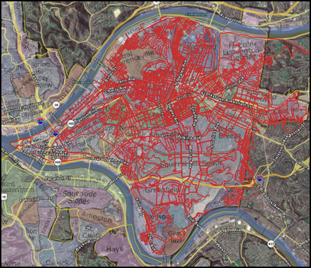
800×687 version
Behold my "Pac Tom" project progress. This last month has been pretty busy as I am trying to finish up my PhD. (The next month or two will also be similarly busy, I expect.) But I have been able to get some running in, because I want a PhD in running too.
I have been continuing my strategy of running the outermost parts of my target area first. Since last time I've finished off Swisshelm Park, Regent Square, Lincoln-Lemington-Belmar (the part on this side of the river), Glen Hazel, and most of the East Hills, which are all peripheral neighborhoods. (In the image above I am using my new pittsburgh neighborhood map that I made for Wikipedia but the color contrast is not very good, sorry.) Even though it looks like there are a lot of gaps in the middle of the map, those are mostly neighborhoods with pretty sparse streets (Squirrel Hill) and lots of parks/cemeteries, so I am feeling pretty good about the feasibility of this project now. I am even starting to contemplate beginning on neighborhoods that are transcontinental, although I think I am going to need to be able to run about 25ish miles in one go in order to do the most distant of those. My max is around 16 now. I keep trying.
In other news, I recommend that you check out Harris Grill's homepage, which has a funny section rebutting the blogosphere's (I am still using this word in a purely ironic way, I promise) reports, including what is unmistakably reference to comments you guys left on my entry below, Harris Grill catches fire. | |
|
r
u
n
b
l
o
g |
Pac Tom update: The Steepest Streets
(04 Jul 2007 at 12:19) |
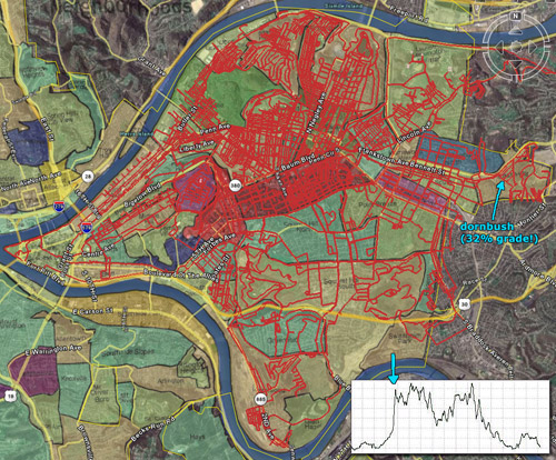
998×826 version
Here's my monthly pac tom update. I've been escalating my attempt in order to improve my chances of finishing before I graduate; aside from the obvious stuff like running more often and for longer distances, I've also been planning my routes more carefully. I now usually draw or print a map before I go somewhere, so that I don't miss a little street somewhere, and I'm also now using an "outside-in" style where I try to run the most distant streets (edges of the city) before the inner streets. If I do that then I'll waste less time later because I won't need to run through inner sections I've already covered thoroughly on the way to outer sections. So, I hope that after doing this, the big empty spots in the map like Squirrel Hill will fall fast.
Neighborhoods totally done: Friendship, Garfield, Morningside. Very close (1 or 2 more trips): Shadyside, Upper Hill, Strip, Larimer, Central and Upper Lawrencevilles, Stanton Heights, East Hills.
Yesterday I took a trip to Dornbush St. in the East Hills. This is the second steepest street in Pittsburgh and the eighth steepest paved road in the US (slightly steeper than Filbert St. in San Francisco) at a 32% grade. 32% means that for every 100 feet traveled in the horizontal, there's a rise of 32 feet. That is really steep!! Check out the preposterous uptick in the elevation chart at the bottom right of the image. If you live in Pittsburgh, you can compare the popularly tilty Negley Ave.—it is less than half as steep at "only" 15.8%. Pittsburgh's steepest street, Canton Ave. is 37%, probably making it the 1st or 2nd steepest paved road in the world (depending on what you count). That's not in my goal area ("continental Pittsburgh") but it I do hope to make it out there just for fun some day. | |
|
r
u
n
b
l
o
g |
Pac Tom report #1
(29 Apr 2007 at 19:19) |
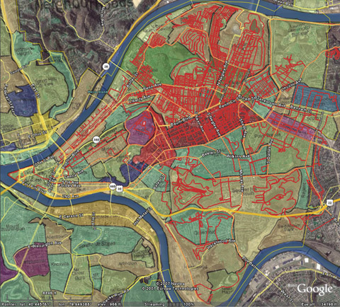
1051×951 version
Most of my local friends know about this because I talk about it a lot, but I haven't really blogged about it yet (except for some oblique references that probably came across as jokes), but I am really doing it and I wanted to update you on my progress: I am trying to run every street in Pittsburgh. I call this "Pac Tom" because it's like Pacman on a larger map without any ghosts or Power Pills. "Every street" comes with a few caveats for this project:- By Pittsburgh I mean (for now) "continental Pittsburgh", which is what I call the part between the Monongahela and Allegheny rivers (roughly half the official area of the city, which is 53 mi).
- I'm not running on most interstates or state roads without any kind of reasonably safe pedestrian access. (I'd estimate there are only about 15 miles of such roads.)
- I'm not requiring myself to run any of the dozens of staircases that are officially marked as streets (!) although sometimes they are good shortcuts.
Other than that i'm really trying to cover everything, using on-line maps and my GPS device. Up above I've posted a map of my progress so far, with my tracks in red—click for a closer view. The colors are the various neighborhoods. I do insist that I'm running whenever I'm moving (no walking!) but usually rest a couple times during each trip. It's difficult to gauge how much I've done (since you can't really see the streets in that map) but I'd estimate that I'm about half way done. So far I've run about 530 miles (many of these miles overlap) in about 74 total hours. If you're curious about the specifics, part of the process of getting these tracks into Google Earth is uploading them to Motionbased so you can check out that list, at least as much as they'll show you for a non-paying user like myself.
I think this is a really fun and worthwhile project. Occasionally it can suck: injuring myself when 6 miles away from home can be a problem, or not being able to find any water (now I carry a little bit of cash so that I can ride a bus or buy some gatorade in a pinch), or running a grid of streets and then noticing that my watch froze twenty minutes ago and all the work was lost (grr!), or running miles down a road to find that there's really no way for a pedestrian to continue, and having to turn back. But it is vastly more interesting than running the same streets every day, and I've found so many cool things that I never saw before in my 9 years in this city, and never would have seen otherwise. I've also really improved my sense of direction in the city—I almost feel like you could drop me off in any place randomly here and I could find a short path back home. (But don't do that.) Pittsburgh has a lot of features that make it particularly fun: its topology in terms of roads (grids are rare) and elevation (it is very hilly) make exploring interesting. But when I end up eventually getting a job and moving, I'm pretty sure I'll do it again for whatever city that happens to be. | |
|
|
|
|