pac tom level 1 trophy.pdf
Hey, this post is to officially announce that I completed Level 1 of my Pac Tom project. That's a big deal for me but I'm kind of over it because I finished over a year ago, in November 2008! I've been strangely silent on the project since I announced almost being done in the August 2008. It's part of a weird pattern of behavior where I finish or almost finish big projects but then never announce them because my announcement ambitions exceed my announcement wherewithal, which would be such a tiny fraction of the total effort expended (which is weird) so I never actually announce them. This particular case is strange because I'm well on to Pac Tom Level 2, spending many hours every week busting my ass on it in various ways. I'm trying to fix this behavior. Pac Tom Level 1 is done! Soon, the Pac Tom website and my substantial progress on Level 2.
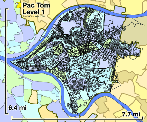
Pac Tom is my project to run the length of every street in Pittsburgh, Pennsylvania, USA. I've been doing it for many years now, accounting for many thousands of miles and many hundreds of hours of running. Level 1 is the area of the city between the Allegheny and Monongahela rivers (see map above), which is 23.5 square miles. Those black lines are the routes I ran, tracked with my wrist-worn GPS device. I always start or end at my home or work, usually both. The background map is my old Map of Pittsburgh Neighborhoods which I made for Wikipedia. Click for a PDF so you can zoom to your heart's content, as long as its content does not exceed the limits of IEEE floating point. I have new maps now which are not as sloppy, but also not as colorful.
And then I have to do this: ACHIEVEMENT UNLOCKED
Every street, continental Pgh | 