r
u
n
b
l
o
g |
Pimp my run
(12 Jun 2006 at 21:13) |
 Today I got a new gadget (you can blame jaked) to aid my quest to run all over Pittsburgh. It's a Garmin "Forerunner" which is a GPS device, specialized for running, in an oversized pimp watch form factor. Seriously, I feel way bling'd out. But it doesn't get in the way and it gives me instantaneous pace and distance information and I can even put it in "ghost racer" mode where I run against an invisible otherworldly partner (perhaps derived from a previous performance, or perhaps extracted from the platonic dimension of perfectly steady incorporeal pace rabbits) like when trying to qualify for the Special Cup on Rainbow Road. Go go, ghost racer! Today I got a new gadget (you can blame jaked) to aid my quest to run all over Pittsburgh. It's a Garmin "Forerunner" which is a GPS device, specialized for running, in an oversized pimp watch form factor. Seriously, I feel way bling'd out. But it doesn't get in the way and it gives me instantaneous pace and distance information and I can even put it in "ghost racer" mode where I run against an invisible otherworldly partner (perhaps derived from a previous performance, or perhaps extracted from the platonic dimension of perfectly steady incorporeal pace rabbits) like when trying to qualify for the Special Cup on Rainbow Road. Go go, ghost racer!
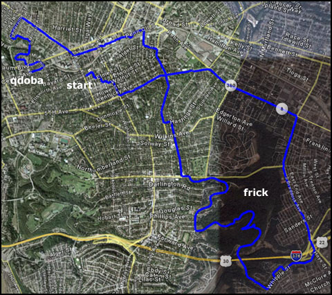
I'm still figuring out the best way to use the data I get from it. There is a shitty GTK app that comes with it, which would have been pretty sweet on Windows 95b, and which thinks that walking 1.0 miles home burns 287 calories. Right. Then there is a web-based app called "MotionBased" which I suppose fancies itself a sort of Flickr of running and biking. I think this could be pretty good, but a lot of stuff isn't implemented yet. I hereby share this run with you. My favorite way to visualize currently is to use the Google Earth export. I used it to generate the image above; you can click this W3C-approved semantic XML document (lol that it is just a list of lat/lon pairs inside a tag) for your own 3D world runner*: qdoba.kml.
* I was a little astounded that the first link I found for this classic uses my font "Action Jackson" in its self-promo!
So this run was 12.88 miles. At some point I was trying to make it a full half-marathon (only .22 miles short, actually) but I spotted a new Qdoba in my neighborhood and was hit with an insurmountable craving for guacamole and hot sauce. Much earlier than that I ran through Frick Park, which I would recommend except for the very uphill and sinuous path to the park itself from pretty much anywhere. I popped out of the woods in like Swissvale on the wrong side of I-376, but the GPS compass helped me get back without having to retrace my steps. Yay!
I think this will be helpful for the Rachel Carson trail challenge in two weeks. We hiked a small segment of it on Sunday as a practice (it's allegedly the hardest part: the "roller coaster" of steep uphills and downhills along the pipeline). It wasn't really that bad, but finding and following the trail can be rough at times, and we will have enough to worry about on the actual day than to look at 30-year old hand drawn topo maps to try to figure out where to go.
In other news, I was suddenly struck with the urge to work on Escape this weekend. Development has stalled for a while because most of the changes I want to make involve ripping out a bunch of more-or-less working code I've already written. So, I needed to like put some emotional distance between me and that before I start chopping, and time heals all wounds except for maybe necrotizing fasciitis. |  |
 |
whoa, dude, I think that the JAG Haus has often talked about the disease you mention; apparently it's one of the few cases where a well-trained dermatologist can save your life.
Nifty gadget and congratulations on an awesome run! Soon you'll be running to Monroeville for fun.
And the maps for the RCT were updated only 11 years ago, not 30. :) |
| Yeah, I think Monroeville is only 10 miles, so if I didn't have to come back I think I'd be all set. ;) |
| Always wear a helmet when you run. |
| Whatever man, Roethlisberger is my hero! |
Tom,
You're right. We pretty much fancy ourselves a Flickr of endurance and outdoor activities. More cool stuff on the way.
|
 |
|
|
|