|
|
 |
I
d
i
d
i
t |
The Pac Tom documentary!
(28 Dec 2022 at 11:01) |
It is done! I finished the Pac Tom project to run the length of every street in Pittsburgh in October, and (yes it took months) also this video documenting the project and finale:
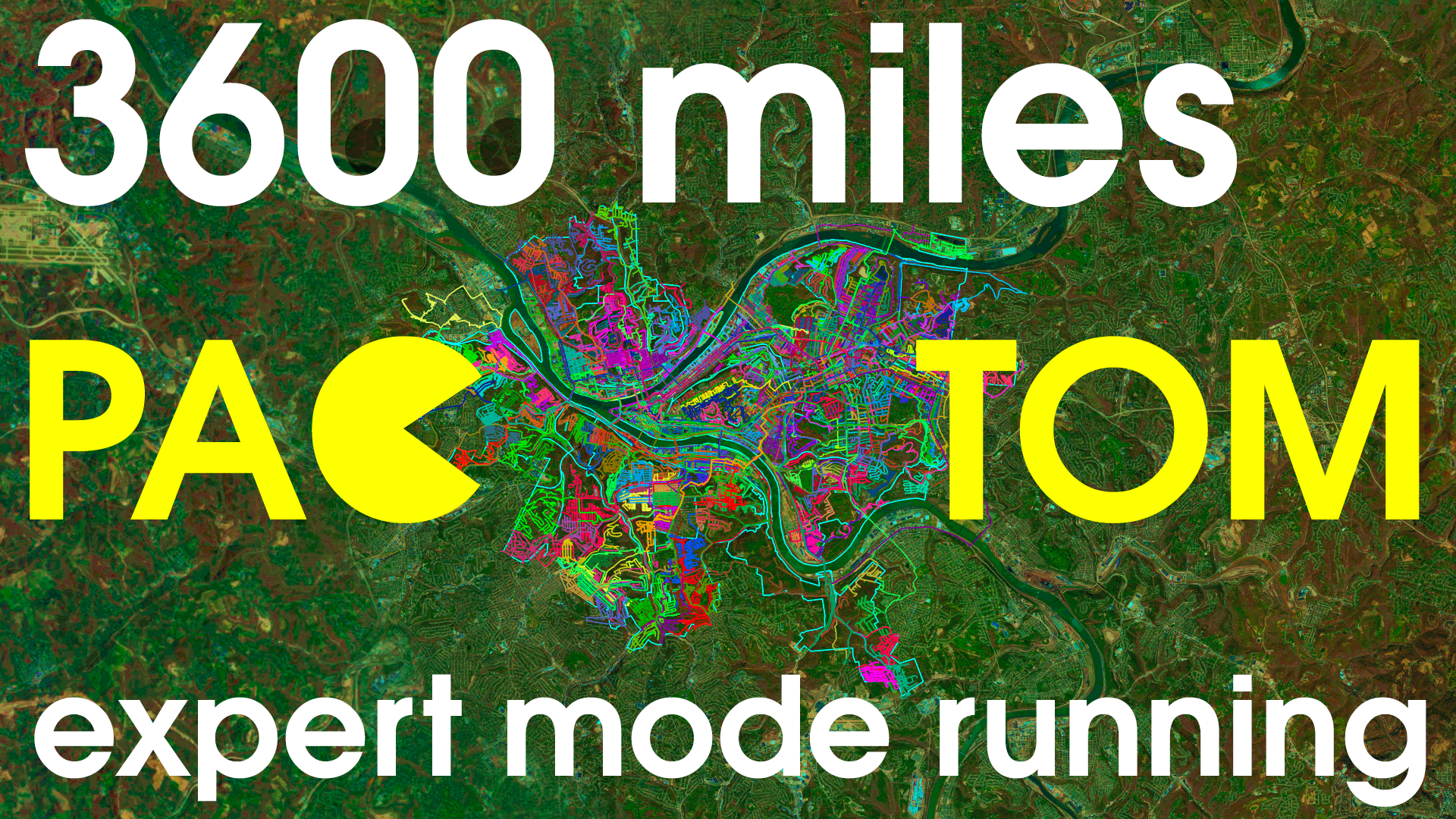
How I ran the length of every street in Pittsburgh: PAC TOM
The Pac Tom site now has the final data, but the video is the definitive way to see it!
I added the downloadable Soundtrack for completionists. I was horrified to find, when watching this video with some friends after I uploaded, that I had accidentally muted one of the audio tracks for the "final" version. You can rectify this by playing "Street (Trap Remix)" at exactly 11:58. | |
|
p
e
r
s
o
n
a
l |
Pac Tom article
(30 Nov 2013 at 09:16) |
Local fame is mine! Here's a writeup of the Pac Tom project in the Pittsburgh Post-Gazette: The man who will run all of Pittsburgh.
Pac Tom is coming along pretty well. I've long since finished the whole of Continental Pittsburgh (area between the two rivers) and the South is all done except for a single run that I will probably use to finish up on Mt. Washington. I've taken a big chunk out of the North Side, with several of the most distant neighborhoods completely done. I've slowed down a bit, partly because I got out of shape after a tough year, but mostly because I'm a little afraid of finishing now! I probably only have about 10 trips left, and after that I'm not sure what I'll do with myself. (I mean my feet. I have loads of projects as usual.) | |
|
p
e
r
s
o
n
a
l |
Needless advancements in shoe tying
(29 Jul 2012 at 15:39) |
Well, just one advancement, which is this:
It may not surprise you to know that I have spent way more than an average amount time thinking about how best to tie shoes (knots were a specialty of mine in Boy Scouts and during my grad school megaprocrastination phase I even staged a bunch of photographs of them for Wikipedia), but it may surprise you that when this vision first struck me I was at first unsure that it was even possible. (Somewhere, someone with basic geometric sense chuckles, the kind of dismissive reflex laugh that is transformed into an awkward fake cough when he realizes from my expression oh, you weren't joking.) Of course pretty much any knot shape you can imagine is possible with both ends free. This one isn't even that mechanically difficult to carry out, though if you are like me then the shoe knots are stored 100% in muscle memory, not like even accessible to your conscious mind, like when you can't remember the particulars of your password's capitalization or the fingering of the Csus4 chord without actually doing it, maybe on an invisible keyboard or guitar. So far, the double-knot version eludes my attempts at dexterity. But I don't like to give up!
I was just about to go out running to work on my Pac Tom project which has not been getting much attention this year for a variety of reasons. Right as I'm about to leave the house with everything ready (as much as a like running for its simplicity, there's the preparatory food and liquids and coffee and ibuprofen, sunscreen which by the way is a real walnut with a beard and general body hair, plus I have this super old Baby Magic brand old dried sunscreen that I found on Ryan's porch and appears to contain an infinite amount of superdense titanium white oil paint, which is the suncreen that I have been using for years because it's not like I'm going to throw this perfectly good old dried immiscible paste out, even though Ryan tells me that it probably contains poison because it dates from pre-FDA era wild West style chemistry times, and then the shoe tying which becomes a thought excursion, and since I just got a new computer I need to install all the mapping stuff on it and transfer it over from the old one, etc.) I realize that my GPS watch, basically the only piece of non-negotiable equipment other than the left and right feet, is out of batteries because of the ill-designed chargey clasp whose design hostility defies explanation other than schadenfreude. That's what's charging now and the reason I'm taking the time to go on and on, instead of actually doing the running, which I'd prefer to do, not just because I feel suddenly stricken with exaggeration logorrhea, though I guess obviously that does happen. We're at 53%. I'm talking about the Garmin Forerunner 310XT here, in case someone on the design team some day scours the internet to find some schadenfodder. The chargey clasp thing is a springy clamp, that you clamp around one side of the watch like a snake face. Its lower teeth are spring-loaded pins that carry the electricity juice into two little charge dots on the underside of the watch. Boy does this not work well! And I'm not talking about like works-at-first NES-cartridge contact malfunction, or even like BART ticket machine designed-by-an-alien-race stuff, more like a carnival game that is designed to trick you to keep putting quarters in. The standard way for this to go wrong is that you put the snake face on, and the teeth go into the little holes on the bottom, but the pins aren't actually contacting the charging nipples because inside the holes there are both metal contact nipples (useful) and waterproof insulating plastic areolae (useless). What is this bullshit?
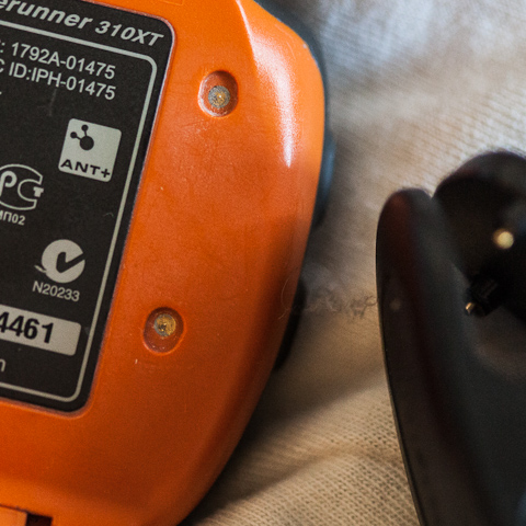
So obviously if either charging tooth is on areola, then it doesn't charge. Even worse, since these are recessed holes and on the side of the watch exposed to skin and trapped corrosive salty sweat and Baby Magic, what little contact area there is tends to get covered up by trapped dried particles or invisible dielectric or electrochemical deposition since these are after all battery contacts. So you learn pretty quickly that when you get the snake face on, you have to jiggle it around to get actual charge contact (you obviously can't actually see in there as you're doing it so it's a bit more like the telemetric feel of lockpicking). You can see on the screen whether it's charging, thank goodness. But this arrangement is pretty unstable, so when you put it down on your computer or whatever, you have to be pretty careful to place it in such a way that the mere act of placing, or any further vibration, like from any dubstep within a few blocks radius, during the time from now until you decide to go on a run, doesn't dislodge the teeth. Which is what happened today. Now here is the most devious betrayal. If the watch becomes dislodged while charging, it reverts to the previous state (on or off). If the watch was turned on when you plugged it in, it turns back on, and then searches really hard for GPS signal, certainly discharging itself in a matter of hours. Awesome! ALSO, you can't tell if the watch is "on" or "off" while it's charging. So you have to remember when you come home from your run to wait for your data to transfer wirelessly to the computer, then turn it off, then plug it in for charging. ALSO, when the snake face is on, it conveniently covers up the power button so that you can't turn it off anyway. I can't quite tell if this is a strange coincidence or a hardware "workaround" to some issue where using the power button while charging would cause it to self-destruct. (Did you ever think it was annoying how you have to take the battery out of your cell phone to change your SIM or memory card and thought that was pretty dumb? This is more likely just a clever way to prevent you from removing or inserting the card while the phone is on, because it can't handle that. Now that's a smartphone!)
Now we're at 75% which should be enough for a North Side jaunt. Next time I will show you some new maps! :) | |
|
p
a
c
t
o
m |
Pac Tom update: Polar adventures in data visualization
(19 Feb 2011 at 23:57) |
For those just joining us, Pac Tom is my now 4½-year project to run the length of every street in Pittsburgh. This update is about a new visualization of the GPS data I collect as part of the project. Behold the most radar-like image ever posted on Tom 7 Radar:
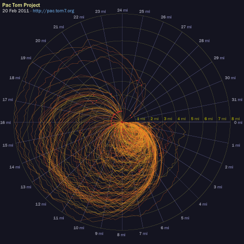
radial.pdf - click to have your face blasted with maths
I'd like to think that my data visualization experiments are self-explanatory, but this one does not have the ability to write or talk so I will do the needful. Each one of the orange lines is a Pac Tom running trip (now a slot-jackpotting 222 of them). The squiggles always start at angle 0, corresponding to 0 miles. They proceed around the radar circle clockwise according to how many Tom-sneaker miles the trip is, with a full revolution being 32 miles. At every point their distance from the center is based on the number of crow-flying miles that I am away from my home, with the outermost circle being 8 miles. Red dot emphasizes the end point. I hope that you appreciate the radial and angular gradations because those were fiddly to make in SVG, particularly the labels.
What can we tell from the graphic? Well, most trips start and end at home. This is obvious from The Rules, which require it. You can see that a bunch of them end about the same distance away; these are all me fizzling out at CMU's campus, where water and HVAC are plentiful, or sometimes where I used to leave my junk. You can also see that there's some consistency to the specifics of the routes both at the beginnings and end (like if you look at those 15–20 mile ones that end at CMU, you see the same jog patterns leading up to those ends, which is me taking the same turn on the way back). There's even a more bold orange laser at the beginning, which basically corresponds to me taking any efficient route away from my house, regardless of where I'm going (it is roughly an Archimedian spiral, where after 5 miles of running I'm about 5 miles away from my house). The most interesting thing to me is that there really is a characteristic shape of a Pac Tom run when plotted this way. A typical runner's route (out and back) would be a prolate ellipsis, actually maybe more like a vesica piscis if the runner gets to the summit overlook or no tresspassing sign or whatever and turns right around. My shorter earlydays runs, which are hard to see because they're all bunched up on top of one another in the South-East octant, are kind of like that actually. But the canonical Pac Tom run now is obovate like a ginkgo leaf, where I run away from home then zig-zag back and forth for many miles, creating the tiny leaf teeth at approximately the same distance, then run back home. There's not even any reason why these would have to be leaf-shaped at all; you can see the few Pittsburgh Marathons in there (those count), which are more like abortive Spirographs.
I had appendix surgery (meaning they just cut it out and threw it in the biohazard) in September and then a work crunch that disrupted my running for a while, but I'm now back to it. I'm getting in decent shape again for the marathon, which I am excited about mostly because of the costume plans. I just polished off large distant neighborhoods Sheraden and Elliott (after a fairly heartbreaking trip where I thought I had at great effort finished, but had missed a tiny 50-foot segment, so I had to go many miles out of my way to get that one yesterday, in really OCD-affirming style. Having done that is actually one of the diagnostic criteria in DSM VII.) and the remaining cleanup to do on the South Side is pretty light and much closer to my home. I think I can be done with those with maybe two months of regular running, and maybe even finish the North Side, which is all that's left, by the end of 2011? 4500 miles in 27 days 15 hours of running, so far. You may track my progress via the graphics at the Pac Tom ultimate cybersite. | |
|
p
e
r
s
o
n
a
l |
Pac Tom September update
(12 Sep 2010 at 00:26) |
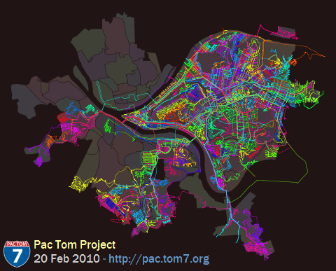
Time for another update on my project to run the length of every street in Pittsburgh, called Pac Tom. It's all about the map:
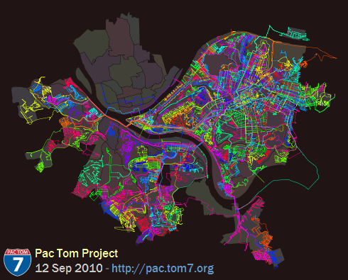
Also available is the same map in PDF so that you can pinch to zoom. Over on the right (known to cartographers as "East") you can see Pac Tom Level 1, totally all done. I've been hard at work on the stuff South of the Monongahela since I finished Level 1 almost two years ago. It's hard because it's far from my house (see rules and regulations) and crazy hilly. You can see that I've made a lot of progress either just by the superbrite color lines all over everything (btw that image above is about 136 square miles, about 140 feet per pixel) which is where I went, or by comparing to last time, or by me being more specific:
Neighborhoods totally done (level 2): Banksville, Beltzhoover, Bon Air, Brookline, Carrick, Chartiers City, East Carnegie, Esplen, Fairywood, Hays, Knoxville, Lincoln Place, Oakwood, Overbrook, Ridgemont, St. Clair, Westwood, Windgap.
Total running events (this includes Pac Tom, training, races, and 3D World Runner): 734
Total time recorded: 25 days, 23:15:38
Total distance: 4230.118 miles
But actually what I really wanted to show you was a newer map, which has been on the Pac Tom site for a while but I have never explained. It's the shortest paths map:
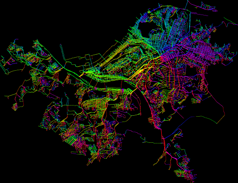
Well, at this view it just looks like the regular map vomited a rainbow all over itself. What's going on is that this is a graph of all of the places I've been (each individual GPS waypoint), connected by heuristics (like they were consecutive in a trip, so I actually ran between them, or they appear to be near enough to imply that I could run between them) and then I compute the shortest path from each point back to my home. Here's a zoom up:
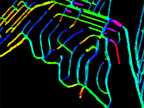
Bonus points if you recognize the neighborhood! See all those fingersnakes reaching up to meet one another? Those aren't dead ends, they're the farthest away from my house I can get on those roads (the leaves in the minimal spanning tree rooted at my house). On one side, the shortest path is to go South, but just a few feet away, the shortest way is to go North. (My house is Southeast from here.) I spent a lot of (fun) time writing this code partly in the hopes that it would teach me about better ways to get out to distant neighborhoods, but it turns out that on city streets (especially grids), the shortest path on foot is usually pretty obvious. Even when it's not, the difference rarely exceeds 100 feet. The most interesting places are probably choke points, like bridges:
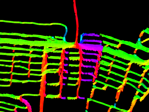
Pretty much everything nearby points up this bridge. The colors by the way are not gratuitous; they indicate the physical heading that I should be running on that segment to decrease my distance to home. Green means East, red means North, violet means West, cyan means South. This is meant to emphasize the break-even points described above. Here you can see from the thickness of the lines (which just comes from having lots of runs through there, with GPS noise) that I don't usually take the Birmingham Bridge, even though it would save me about a South Side block's width (that's the pink stuff: Turn around!) I usually prefer the Hot Metal Bridge to the East because it's got better pedestrian access and also my brain autopilot is accustomed to the area, having run it like a hundred times. Unfortunately it's hard to get route preferences (and other stuff like elevation change) incorporated into the formulas. So, rainbow brite indeed but not actually that useful. The maps are updated automatically after every run onto the graphics page. You can check out the source code which of course is mostly calls out to general-purpose libraries for loading GPS data and computing fine-grained distances on the earth pear's surface and undirected graphs and snapping the neighborhood boundaries to be exactly perfect, and outputting the SVG, all of which I of course wrote myself even though it probably or certainly already exists because have you MET Tom? | |
|
p
e
r
s
o
n
a
l |
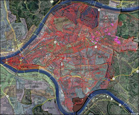
Pac Tom website and Level 2
(21 Feb 2010 at 12:44) |
I'd like to introduce you to the Pac Tom website, where I'll be organizing my project to run the length of every street in Pittsburgh. New look, look:
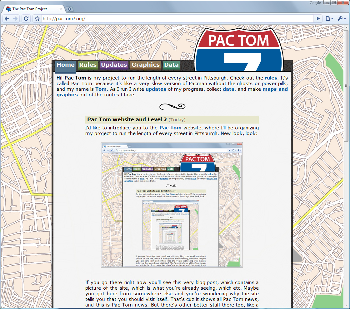
If you go there right now you'll see this very blog post, which contains a picture of the site, which is what you're already seeing, which etc. Maybe you got here from somewhere else and you're wondering why the site tells you that you should visit itself. That's cuz it shows all Pac Tom news, and this is Pac Tom news. But there's other better stuff there too, like a new description of the rules, downloadable KML files of my routes, and brand new maps. Here's the main one:
In post 1039 I congratulated myself on finishing Level 1, which is all the roads between the Allegheny and Monongahela rivers (conspicuous sinuous voids in the map above). That was over a year ago, and since then I've made significant progress on Level 2, which is the rest of the city. Each of the colors in the map above is a different trip, though some trips get the same color because there aren't that many colors and they're assigned randomly. I finished off the remote colony of Lemingon-Lincoln-Belmar that's across the river to the far Northwest in one go. (It's pretty weird that this is part of the same neighborhood or even part of Pittsburgh; it's almost entirely a shopping plaza. Must be a tax thing.) The rest of the year has been spent on the neighborhoods to the south of the Mon.
This is way harder than Level 1 was. Obstacles: It's about 6 miles of running just to get from my house to new roads, which I also have to do on the way back, so a minimal trip is 12 miles; they're usually more like 20 so that I can get deep down there and then cover some streets. You can tell from the map that I've been favoring the roads that closest to the borders. I like to do this so that I can "finish off" the periphery and not have to worry about it again; on the way there and back I can pick up some new roads shotgun style. (I'm almost done with South Side flats only via taking different routes through it on my way to other places.) The furthest points imply about a 30-mile round trip (you can see them way off to the West). I haven't done those yet, but I have done some 30-mile trips, so I know it will be possible and painful. Obstacle #2: This area of the city is ridiculously hilly. Level 1 sure had some steep streets but the South Side and West End are worse. Just getting there means running up the Slopes or Mt. Washington, and then the hills roll on. Garmin Connect, which is what I hook my GPS into, pretty much always assumes that the physical activity I'm doing is "Stair Climbing" based on the elevation change. The steepest paved road in the world is there, in Beechview! I'm not complaining, though. I love it.
One of my favorite things to do with the thousands of miles of GPS data that results from the project is various visualizations and computation. There are some more maps on the site and some more coming. I'll post about these soon. | |
|
r
u
n
b
l
o
g |
Pac Tom Level 1 Complete, trophy
(30 Jan 2010 at 11:21) |
pac tom level 1 trophy.pdf
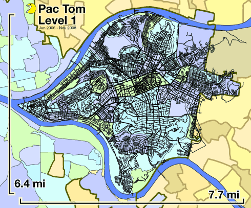
Hey, this post is to officially announce that I completed Level 1 of my Pac Tom project. That's a big deal for me but I'm kind of over it because I finished over a year ago, in November 2008! I've been strangely silent on the project since I announced almost being done in the August 2008. It's part of a weird pattern of behavior where I finish or almost finish big projects but then never announce them because my announcement ambitions exceed my announcement wherewithal, which would be such a tiny fraction of the total effort expended (which is weird) so I never actually announce them. This particular case is strange because I'm well on to Pac Tom Level 2, spending many hours every week busting my ass on it in various ways. I'm trying to fix this behavior. Pac Tom Level 1 is done! Soon, the Pac Tom website and my substantial progress on Level 2.
Pac Tom is my project to run the length of every street in Pittsburgh, Pennsylvania, USA. I've been doing it for many years now, accounting for many thousands of miles and many hundreds of hours of running. Level 1 is the area of the city between the Allegheny and Monongahela rivers (see map above), which is 23.5 square miles. Those black lines are the routes I ran, tracked with my wrist-worn GPS device. I always start or end at my home or work, usually both. The background map is my old Map of Pittsburgh Neighborhoods which I made for Wikipedia. Click for a PDF so you can zoom to your heart's content, as long as its content does not exceed the limits of IEEE floating point. I have new maps now which are not as sloppy, but also not as colorful.
And then I have to do this: ACHIEVEMENT UNLOCKED
Every street, continental Pgh | |
|
r
u
n
b
l
o
g |
Pac-Tom Update: October 2008
(11 Oct 2008 at 16:03) |
800×645 version
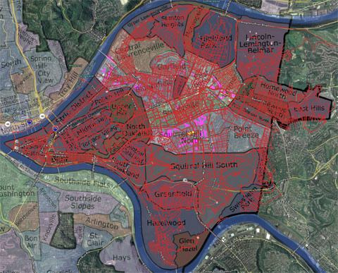
Okay, we'll make this one quick. I spent a lot of time this summer training for races, which cut into this project to run every street. I still occasionally made some progress on that, and now that I'm back in town without any races coming up I'm on it full-time. Like I mentioned last time, the name of the game now is to finish up those scattered spots I've missed and eliminate neighborhoods one at a time, concentrating on the more distant ones first. Newly added to this list are all of the Oakland neighborhoods and Squirrel Hill South, which is the largest neighborhood in the city (by area), and really hilly. Phew! The finished neighborhoods are darkened in above and pink are individual marked-for-death roads. It certainly looks like I'm almost done, huh?
Total distance: 2208.5 miles.
Total time: 12 days, 15 hours, 15 minutes. | |
|
r
u
n
b
l
o
g |
Pac Tom: August 2008 Update
(17 Aug 2008 at 19:04) |

1000×874 version Okay, time for our bi-monthly Pac Tom project update. This summer has been very productive for pac-running, mainly because of the long daylight hours, free weekends, and need for introspective time. That's even given the marathon training and now the Great Race training, which mostly consists of running the same course over and over every day. (The upshot is that being in good shape means that on those weekends I can go a lot farther, and since my Pac-efficiency is dominated by the amount of the graph that I can cover once I get out to some distant neighborhood, being able to run twice as far in one go means much more than a 2x improvement in Pac-coverage. I mean if six of my ten miles are just getting to the neighborhood and back, then if I add another ten miles, all ten of those can be used to cover the streets in that 'hood.) Progress update below but first some recent running tales.
Last weekend when I got back from California I must have still smelled like San Francisco or something because I was offered the opportunity to buy drugs by this not-drug-dealer-looking middle-aged woman. I think it is pretty weird, because she was just sitting at a bus stop and then I run by and I don't think I'm like exuding "hey, sell me some pills," and also if her biz is based on waiting for people to jog by this bus stop with cash, she is probably going to not be doing a lot of volume because I would not be surprised if I'm the only person to have run that particular street in 50 years. Anyway she's like, "Excuse me," in a whisper, "Do you know anybody that needs some Vicodins®?" Vicodins® plural, which is not how I'd say it. Normally I like to answer solicitations in very genuinely polite but confusing ways, to decline in a totally new style with no easy retort on the person's solicitation flowchart (to use a Chess metaphor, I like to get "out of book" as quickly as possible) because that is more or less pleasant for both of us and funny to me. For example, when the other lady on the phone is trying to sell me the Caller ID feature, I tell her as genuinely as I can, "I like the uncertainty of not knowing who's calling," and how can she argue with that? I'd like to have provided a similarly confusing answer but really, she had me out of book on the first move, so I was just like, "Uhhh, sorry!". And this wouldn't even be that remarkable (even though it's the first time I was ever offered drugs by a stranger in Pittsburgh) except that less than an hour later on the same trip but in a different neighborhood some kids ask me when I run past, "Do you have any marijuana?" And I'm like whaaa? To be truthful I think these kids were just making fun of me, which is pretty common when I am running in places where I am out of context and I am totally okay with that, but I don't really know why that would occur to them or in what sense that was making fun of me. Some cut-elimination or market-optimization part of me thinks I should have pointed the kids in the direction of the Vicodins® lady to solve two problems. (Once I saw a funny thing in the classifieds section, which might have even been some weird art-joke, which was two adjacent ads, one being a Want-To-Buy ad and the other being a For-Sale ad, both for the same object, described in an unusually and apparently fortuitously similar way. I wish I had saved that.) But I don't really believe in the free market or getting drugs in the hands of kids. Also I feel compelled for some reason to remind readers that I do not do drugs unless you count beer and coffee, which maybe you should count, but I would not use the word "do" for those. Once Percocets® by prescription for the wisdom teeth.
Yesterday I ran 18 miles in Homewood to try to finish it off, with a carefully prepared map and everything. It (the temperature) was hot. When I was finishing up I was super thirsty and I remembered that my favorite Pittsburgh beer-brewery, East End Brewing Co. was having its "Growler hours" at that very time, which hours are a way of selling their beer in jugs in an atmosphere that is almost pub-like without requiring a liquor license or drink-tax liability. And that brewery happens to be in Homewood. So even though I was sweaty-gross and only had three emergency dollars, I figured I'd never be running through this neck again especially during 'hours and boy was I thirsty, so I'd pop in and see if they'd be willing to sell me a non-jug-sized "sample" for those three bucks. I told them my deal and the dudes were like, sorry, but you cannot buy samples because they are free. But it was explicitly cool with them to get several samples even though I was very clear that I was not buying a growler just then (though I drink these dudes's beer all the time so I don't know why I felt like I was scamming them or something and I left my three emergency dollars as a tip), so that was awesome of them and man does cold beer taste good after one runs 16 miles in the sun. The two miles after that are a little bit jostly in the stomach though, I mean because of the CO2. I don't know how the Hash House Harriers people do it. So but when I got back I checked my work and I was happy that I had found all the little side streets and dead ends and had covered them, and as I was about to mark this neighborhood off as done, I saw this gaping, glaring section missing from one of the main thoroughfares through the neighborhood, which I guess I missed because Google Earth colors such majorer roads in as yellow instead of white. Whatever. That sucks, so today I made another ten mile trip out there to get that segment, and also to finish up Point Breeze North while I was at it because it sucks to make a long trip for just three blocks, even if I'm kinda beat.
The name of the game these days is making a serious concerted effort to finish off neighborhoods for good. I can typically finish off one or two neighborhoods each trip. You can see from the blackened areas which neighborhoods I've finished completely; relative to last time this number is greatly increased. 19 neighborhoods remain in the target area, so probably no more than 19 long trips left. I'm a little sad to be done with some of these places and to probably not have occasion to go back, but oh well. Exploring new places is better. Numerology:
Since the beginning of time, 476 distinct running events. (This includes everything, races, training, Pac Tomfoolery) Total time running: 11 days, 14h53m13s. Total distance run: 2020.096. Finally broke the 2 kilomile barrier! | |
|
r
u
n
b
l
o
g |
Pac Tom update: June 2008
(07 Jun 2008 at 20:02) |
1007×836 version
Blam! Three posts in two days, after there being only 2 total posts last month, because I like to keep you guys guessing about the probability distribution that determines whether a post will be deposited in this internet weblog at any given time. I know that these Pac Tom updates are pretty monotonous, but they can't be any worse than some bloggy "Today I ate eggs and Jenny said that Kevin kissed Ethel" stuff, so too bad for you.
Today I ran downtown to do cleanup, a trip that turned out being about 21 miles (it is hard to tell for sure since the GPS works very badly when there are tall buildings around and you are running through alleys and under bridges, and plus the GPS was just working badly today for reasons I can't scrute because it was 90°F and sunny which seems like would be pretty good for satellites). Actually downtown is the worst for Pac Tomming because it is far away and because of the GPS issues (and so I have to meticulously mark of the streets I've done, sometimes from memory) and there are lots of people and cars who think you are weird for running there and sweating on their alleys and under their bridges. And there are lots of highway interchanges and other basically off-limits deadly stuff. AND downtown has some of the worst public water fountain availability, the only ones I know of being at the Point State Park which is currently under reconstruction. Today I was a little lucky that the Three Rivers Arts festival was going on and they will sell you a cup of mostly ice lemonade for $5, which is exactly the amount of emergency currency I was carrying, and ice is solid water anyway which turns into liquid water pretty quickly at 90°F, which liquid is my heart's desire. But it was not enough! On my way back I drank out of someone's garden hose faucet hook-up in the Hill district and I wasn't even sorry. Now downtown is totally done and good riddance to it. I also finished up the Bluff today, which is the location of Duquesne University's campus. An unexpected discovery of this exploration is that Duquesne has a pretty interesting and nice campus, which you might never notice if you only see it from the Hockey stadium side. There are grassy areas and fountains and private drives and little tucked-away nooks with outdoors religious memorabilia like gated plaster statues of ladies clutching babies. Since it's on this huge hill there are lotsa cool views of downtown and the rivers and the penitentiary and lots of three-dimensional topography that you can go over or under (like skywalks and that tunnel that Ben Roethlisberger smashed his football head near). These people don't drink water, I think, because they have no outdoor water fountains. A new feature of my obsessive-compulsive mapping is that I'm now endarkinating each of the neighborhoods that I've carefully validated being completely done with, and will never visit again except maybe on the way somewhere else. These are: Downtown, Bluff, Glen Hazel, Regent Square, Highland Park, Morningside, Stanton Heights, and Upper Lawrenceville. Swisshelm Park, East Hills and Hazelwood are each less than 50 feet of road away from being done, but I missed some tiny street in each of them that I have to go back for. Glowing purple stuff is my todo list, since for some neighborhoods it's easier to mark the stuff I haven't done than the stuff I have.
Stats: 9 days, 22 hours, 40 minutes, 17 seconds. 1718.356 miles.
By the way, I shaved my beard by contractual obligation when the Penguins lost the Stanley Cup finals. Now I have a weird anti-tan where my beard was. | |
|
|
|
|